

On Monday, March 8, 2021, C-Map announced the release of two new electronic charts for boaters and fishermen that are compatible with Lowrance, Simrad and B&G units. As explained by C-MAP Vice President Max Cecchini, these two charts, DISCOVER and REVEAL, replace the MAX-N-+ range by improving the functionality and simplifying the use of these electronic charts.
The C-MAP REVEAL card
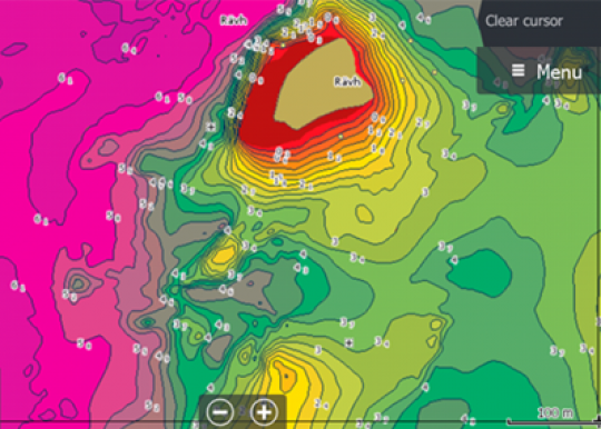
- Shaded relief
The REVEAL series is a real revolution and meets a strong expectation from fishermen, whether they are freshwater or sea anglers, as this cartography offers a shaded relief. Previously available in a local version with a limited geographical coverage, these maps have a worldwide coverage.

Based on ultra-high definition bathymetric imagery, these maps offer you a 3D rendering of the underwater relief. This feature will surely delight fishermen and opens a new dimension on the prospecting and discovery of new spots.

- Dynamic raster
These new maps also offer a "dynamic raster" layer, i.e. a traditional cartography as you can find it in paper format on which you have access to all the objects indicated on it, in addition to an aerial photograph. The whole point of this layer is to simplify access to marinas, for example to locate a specific place to dock. In addition, there is a layer of satellite views to facilitate the location of near-coastal areas if you are sailing in an unfamiliar place.

- Other features
In addition to these features, C-MAP REVEAL maps offer a multitude of layers, some of which are of major interest to fishermen and boaters, including
High resolution bathymetry to determine the precise relief of the bottom and to locate the slightest drop-off.

C-MAP DISCOVER Card
Mainly intended for pleasure boating, this map offers all the essential functions that the boater is looking for.
- Full vector maps and high resolution bathymetry
As with the REVEAL chart, this series includes the vector layer (extracted and updated with hydrographic data) which provides all the detailed information you need to navigate safely and serenely.

- Custom depth shading
This feature will be of interest to boaters who want to set a safe depth, as well as to fishermen looking for a particular species living at a given depth. At a glance, you will identify the targeted area.
-
Customize the color of the depths with the C-MAP cards. -
If you add to this the tides and currents, you will have a fairly complete cartography if you wish to combine boating and occasional fishing.

Features of the C-MAP REVEAL and DISCOVER cards
(R: features available on REVEAL card - D: features available on DISCOVER card)
- Shaded relief R
- Full vector maps R /D
- High resolution bathymetry R/D
- Custom depth shading R/D
- Dynamic Raster Maps R
- Easy Routing with Easy Routing? R/D
- Aerial photographs R
- Satellite image overlay R
- Tides and currents R/D
- Detailed maps of marinas R/D
- Ports and Approaches R/D
- Online updates - including free online updates for 12 months R/D
- Compatible with Lowrance chartplotters ® Simrad ® and B&G R/D


