A nautical chart is an essential document for safe navigation at sea. It can be carried on board in various formats, paper or electronic.
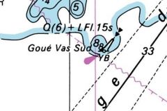
Looking at a nautical chart, you can see that there's a lot of information. Colors, scales, symbols and letters guide the sailor. It's essential to understand all this information, or at least to know how to find it!
Before setting sail, it's highly recommended to look at the chart. The first reason, of course, is to check the depth at every point, so you know you're not going to hit a rock. If you avoid looking at the chart, the rock won't avoid you! However, on the map you'll find probes, not depths. The video will explain the difference between these two terms and also introduce the notion of water height. The second reason is to know your itinerary well, to know your next landmarks and to anticipate a shelter or a plan B in case of unforeseen circumstances.
If you're sailing in tidal waters, you need to understand and take account of this phenomenon. It obviously has a direct effect on depth, but also on marine currents. The latter can be very strong in France! With the right preparation and perhaps timing, you'll be able to exploit them to reach your destination more quickly. If you're not so lucky, they can make situations very complicated, in the event of engine damage for example!
In this video, you'll find all the basics you need to understand tides and how to read a nautical chart!


