The 12th rule is an empirical method widely used by navigators to estimate the evolution of sea level during a tide. Fundamental for yachtsmen, it enables them to anticipate the height of water available in channels, harbours and tidal zones, thus avoiding the unpleasant surprises of unintentional grounding.
The tidal phenomenon: a cyclical movement influenced by the moon
Tides are the result of the gravitational attraction of the moon (and to a lesser extent the sun) on the earth's water masses. They follow a semi-diurnal cycle, with an average of two high tides and two low tides per day. The time between high and low tide averages 6 hours 12 minutes.
However, sea level neither rises nor falls in a linear fashion. This is where the 12th rule comes in.
How does the 12th rule work?

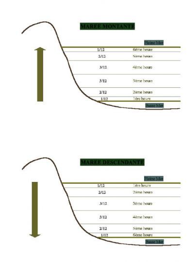
This rule indicates that the rise or fall of sea level follows a curve of acceleration and deceleration. During each tidal period (about 6 hours), the volume of water displaced is distributed as follows:
- 1st hour: 1/12th of total tide height.
- 2nd hour: 2/12ths
- 4th hour: 3/12ths
- 5th hour: 2/12ths
- 6th hour: 1/12th
This means that the tide is faster in the middle of the cycle and slower at the beginning and end.
Practical navigation application
Let's take a concrete example: let's assume that the difference between low water and high water (tidal range) is 6 meters. The sea rise would be distributed as follows:
- After 1h: 0.5 m
- After 2h: 1.5 m (0.5 + 1)
- After 3h: 3 m (0.5 + 1 + 1.5)
- After 4h: 4.5 m (0.5 + 1 + 1.5 + 1.5)
- After 5h: 5.5 m (0.5 + 1 + 1.5 + 1.5 + 1)
- After 6h: 6 m (high water reached)
This rule is invaluable for assessing water levels in harbours, access to channels and planning controlled groundings.
Limits of the 12th rule
While this method remains a useful approximation, it does not take into account :
- Tidal coefficients, which strongly influence the height and duration of the tidal range.
- The configuration of the seabed, which can slow down or speed up ebb and flow.
- Meteorological influences, in particular winds and atmospheric pressure, which modify water height.
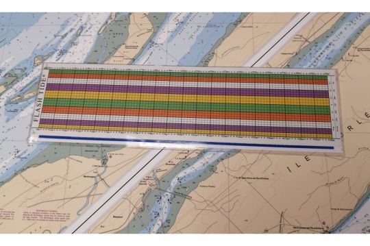
Get help with the FlashTide tide calculator

A good option is the FlashTide tide calculator, a graphical tool that lets you find out the height of water at any time of day simply by drawing a straight line with a pencil. Easy to use, it eliminates the need for calculations using the rule of twelfths.


