Words to describe a sea in motion
The sea is never still. Even in calm weather, it undulates, breathes, moves. To describe this dynamic, sailors, meteorologists and navigators use a precise vocabulary. This lexicon enables us not only to draw an accurate portrait of the sea at a given moment, but above all to anticipate its evolution.
Rather than talking about "big seas" or "impressive waves", bulletins are based on objective data: wave height, frequency, direction and regularity. Today, these parameters are measured by buoys, satellites and numerical models.
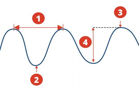
- Wavelength and period
- Hollow
- Ridge
- Amplitude or height
Significant height, a not-so-ordinary average
When it comes to wave height this is not the exact size of each peak, but a statistical average. More precisely, the significant height is the average of the highest third of waves over a given period.
It's a value that sailors keep in mind, as it's a fairly accurate reflection of what we perceive during navigation. In other words, if Météo-France announces a 2 m swell, this means that a third of the highest waves are around 2 m high. But beware: some crests can be much higher than this average. It's not uncommon to encounter isolated waves reaching 1.5 to 2 times the significant height announced.
The medium wave, gentler but less representative
Alongside the significant height, there is also the medium wave calculated this time on all the waves observed. It gives a general idea of the state of the sea, but is often inferior to what is actually felt on board.
In navigation, this value is of limited use. Rather, it is used in oceanography or marine engineering, for long-term studies. Navigators, on the other hand, are mainly interested in the significant height to anticipate their boat's behavior.
The period, the rhythm of the waves, the rhythm of the boat
Visit period is the time elapsing between 2 successive peaks. It is measured in seconds. A wind-driven sea will have a short period, of the order of 3 to 7 seconds. A well-established swell will have a longer period, often in excess of 10 seconds.
This is crucial, as it influences the way the boat reacts to waves. A short sea often produces a dry, unpleasant pitching motion, while a long swell generates wide, sometimes gentler but more treacherous movements.
In short, the longer the period, the further apart the waves are, and the more time they have had to organize themselves. A slow but deep roll, typical of an offshore swell, can be exhausting over time, especially on sailboats.
Direction, where does the swell come from, where do the waves go?
Visit swell or wave direction is always expressed in degrees, depending on the origin of the movement. A westerly swell (270°) means that the energy is coming from the west and heading east.
This is an essential point to take into account in your sailing strategy. A beam swell can make progress uncomfortable, even dangerous, especially on low-stability boats. Conversely, a well-managed tail swell can accelerate progress and lighten maneuvers.
The steering also enables you to anticipate areas of rough water, tricky passages close to the shore, or the effects of heave in narrow passes.

Frequency, wavelength and trough: complementary concepts
In addition to height and period, we can also talk about frequency which corresponds to the inverse of the period. The higher it is, the closer together the waves are.
Visit wavelength measures the horizontal distance between two peaks. It increases with the period. A long sea will therefore be made up of waves spaced several tens of meters apart.
Finally, the hollow refers to the depth between the top of a wave and the lowest point before it. It contributes to the "roller-coaster" feeling at sea and can make navigation difficult, even if the announced heights remain modest.
Reading a weather report through the eyes of a sailor
Once you've mastered these terms, reading a weather report takes on a whole new meaning. A 1.5-meter swell, with a 12-second period, coming from the northwest, heralds long, steady but powerful seas.
A 20-knot wind from the southwest in opposition to this swell can create short, confused cross seas.
These subtleties are invaluable when choosing your course, adjusting your sails or deciding to postpone your departure. Understanding words is already understanding the sea.
The figures announced in marine bulletins are not abstractions. They reflect a very real sea state, with concrete consequences for navigation. Period, significant height, direction, trough or wavelength, these data are the sailor's tools for reading the sea even before seeing it.

 /
/ 