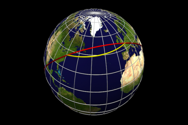
During major ocean races, such as the Route du Rhum or the Vendée Globe, you may have observed on the maps the curved shape of the skippers' trajectories. This is due to the projection of the globe, a spherical surface, on a map, a flat surface.
This projection necessarily leads to deformations. To plot our routes on a nautical chart, it will sometimes be necessary to take into account the roundness of the earth, this is what we call the orthodromic route.
The earth is spherical and yet our maps are flat
Since the earth is a sphere, it is impossible to have flat maps that are absolutely in line with reality.
To be convinced, you can open a balloon in half and try to flatten it out. We will soon discover that it is impossible to do this except by distorting the top and bottom: we do not move from 3D to 2D without consequences.
Thus, geographers have applied acceptable deformations to "flat" projections. There are different projection models and marine charts are generally of the "Mercator" type.
The Mecator projection
This projection dates back to 1569. At that time, most of the world had just been discovered. It has established itself as the standard planisphere thanks to its precision for maritime travel.

The Mercator projection, called conforming, preserves the angles. And let us agree that for us sailors, this representation of the globe is very practical. It allows us to draw straight lines on our maps, the coordinates of which can be read at any point.
What do you mean marche??
This vision of the world consists in projecting each point of the globe onto a cylinder that will be rolled out to obtain a flat map.
Each parallel (to the equator) will have the same length on the map when in reality, on the globe, this is not true.

We notice that the Mecator projection is very realistic near the equator. But the real surfaces closest to the poles are deformed.
And for navigations close to the poles, other more relevant projections will be used, such as that of Postel, which places the North Pole in the centre of the map.
So, what is the difference between orthodromics and loxodromie??
Now that we have seen that our maps are an approximate representation of the globe, we can better understand the difference between "loxo" and "ortho".

The loxodrome is the straight line we draw on our Mercator maps.
It is the equivalent of a trajectory followed by a ship on a constant heading. For example, to reach Marie Galante (West Indies) from Mindelo (Cape Verde) you will follow a long road at 260°.
This route is the easiest to trace on a paper map. But on a large scale, especially when moving away from the equator, it does not correspond to the shortest distance to travel on a globe.
The shortest distance to travel on a sphere is the orthodrome. This term comes from the Greek dromos (run) and ortho (right), and means running in a straight line.
For a ship, it is the most direct line (the shortest) between 2 points on the globe.
But orthodromics is also the most complex route to follow. By taking into account the roundness of the earth, it requires sailors to constantly change their course.
Does the transition from a sphere to a flat map change my navigation??
In theory, the distances recorded on nautical charts are inaccurate.
But let us be reassured, in practice, the error is totally negligible, because our most common navigations do not exceed a few hundred miles. In addition, at the equator and up to 15° North, the loxodromic and orthodromic routes almost merge.
To simplify life, we accept a slight imprecision. This is the loxodromic route we draw on our Mercator map.
But as we move closer to the poles, the gap becomes significant. And for long distances, the gaps can become significant. So to optimize the route, we will take into account the roundness of the earth and the platitude of our maps, it is the orthodromic route.
A practical case study
On a journey from Cape Horn to Cape of Good Hope, the loxodromic distance (constant heading) is 3822 mn.

While the orthodromic distance is 3612 mn is a gain of 210mn.

On the other hand, on a trip between Brest and Marie Galante (West Indies), the difference is around 30 miles, which is negligible for a yachtsman.
How to take into account orthodromie??
To calculate the error due to the Mercator projection, it will probably be necessary to summon the gods of trigonometry. Alexandre Pierre Givry, at the end of the 19th century, developed a formula that corrected the angle measurements taken from a Mercator map to obtain angles on the Earth's sphere.
Come on, for the adventurers of numbers see the link at the bottom of the article.
For those who have returned, let's face it, this method is very tedious. So we're going to simplify the life of the navigator and helmsman. Several loxodromic routes can be reported following the orthodromic route closely. To do this, a new segment will be arbitrarily determined every 10° or every 5° of longitude.

The question of the way forward will most often be resolved with the help of electronics. In most cases, your GPS integrates the calculation of the orthodromic route and will show you the course to follow for the shortest route. The same goes for your navigation software. For example, the Adrena program allows you to choose the route mode for reading distances and heading or for calculating routing.
So loxo or ortho??
We are not airline pilots flying around the globe in all directions. Then on a sailing cruise we will be satisfied with the loxodromic simplicity.
The maritime environment often reminds us that there are not only orthodromic and loxodromic routes on our planet sea. Each navigation is an opportunity to discover routes that are available or imposed on us. Often, our beautiful trajectories are oriented by the wind, which will blow fairly hard or not, in the right direction or not.
For a sailing transatlantic race, a perfect orthodromic route through a high pressure area (without wind) would be of no interest. We would be wise to choose the trade winds route, longer, but windy enough to allow us to cross an ocean.
Sailing is adapting. A great sailor often said, "If you want to make Neptune laugh, tell him about your sailing plan."

 /
/ 